
Geane & Sherryl's Guidebook
Sightseeing
Port costa article
A few miles in, overlooking the strait at the edge of the East Bay, is the destination: a charming port town named Port Costa — a town stuck in amber, honoring its past through near-total preservation, but navigating how to maintain its footing in the present.
And despite its charming, placid exterior, never have I felt like such an interloper, an intruder even, in a Bay Area place as I have during a day trip to Port Costa from my Oakland apartment on a Sunday afternoon.
To be clear, there was no hostility or ill will from any of the residents; just a feeling that visitors could hang out so long as we didn’t overstay our welcome.
Port Costa was settled in 1879. It was a massive grain port with two major sister railroad ferries, the Solano and the Contra Costa. As connectors to the Central Pacific Railroad, the ferries were the largest of their kind at the time, transporting dozens of train cars across the strait on any given day up until 1930, when the ferries were decommissioned. (Metal scraps from the Solano were used as a breakwater for the nearby San Joaquin River.)
According to the Port Costa Conservation Society, the town was home to as many as 3,000 people at "the peak of the grain season" — many sailors and railroaders likely coming for the work. A less romantic notion in some accounts of Port Costa also suggests that the town was popular among vagabonds, who cherished the seedy, rough-and-tumble culture of the town.
Now, fewer than 200 people reside in Port Costa, despite sitting just an hour away from San Francisco and Oakland, and even closer to the sprawling suburbia in Contra Costa and Solano counties.
Its proximity to nature, relative to much of the surrounding Bay Area, is staggering. The strait, which is fed by the San Joaquin and Sacramento rivers, is picturesque, but ever so often interrupted by the blare of an Amtrak or Union Pacific train shuddering by. (Locals don’t seem especially happy that the city is cut by railroad tracks, inhibiting access to the strait, despite the town’s historical ties to rail systems.) A few steps away from the Catholic church are bluffs bordering the strait, fenced away by East Bay park officials.
Signposts of its history permeate Port Costa. At Canyon Lake Drive, the town’s primary corridor where its main shopping drag stands, dates fill plaques, as if Port Costa were one living, breathing timeline of the Bay Area’s unvarnished past. The church, just off this main street, was founded in 1898; a fireproof wheat storage unit that serves as a visitors’ outpost was built in 1886. The latter’s plaque lists out all the tragedies that it survived, the earthquakes and fires that have decimated many Bay Area historic landmarks.
(The plaque also doubles as a tribute to James Phelan, the former San Francisco mayor who played a key role in the city’s recovery after the 1906 earthquake, as well as the push to eliminate Chinese and Japanese migration to California.)
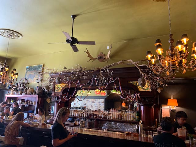
The Burlington Hotel, founded in 1883, boasts a worn, ornate quality, featuring 21st century renovations done in 2013, but the signage outside is the main draw. It advertises that it was once a bordello, a brothel, during its late 19th century heyday. Rumors also abound online that the hotel is haunted by the ghosts of former partiers and guests.
In the early 20th century, the Burlington Hotel was also seemingly a popular destination for grifters of all stripes, again the town’s seedier appeal is palpable. Tales littered newspapers at the time of a thieving hotel clerk making away with hundreds of dollars and a San Francisco innkeeper leaving his wife and hopping on a train with their joint savings.
A wishing tree stands on the same street just a few yards from the hotel, with hundreds of tags seemingly tied during the pandemic. I opted not to read any; it didn’t feel like my place to pry on what locals wished for.
Bull Valley inn has Incredible meals. No reservations, but worth the wait.
Port Costa Conservation Society
1 Plaza Del HambreBull Valley inn has Incredible meals. No reservations, but worth the wait.
Benicia Historical Museum at the Camel Barn
The Benicia Historical Museum shares the story of Benicia’s place in the history of California and how this history relates to the development of our country pre- and post statehood.
The job of collecting artifacts began in 1975 and the items were stored in several locations until our current site in the Arsenal became available. The Benicia City Council dedicated the Camel Barn complex on December 7th, 1982. The Museum was formally dedicated on May 19th, 1985 and has been open continuously since that time.
The name, Camel Barn Complex, comes from a chapter in Benicia’s contribution to US Military history. In the 1850’s and 1860’s, the US Army experimented using camels, imported from the Mideast, as pack animals. After the advent of the Civil War the experiment was abandoned. The remaining camels were shipped to the Benicia Arsenal where they were auctioned to the public. You can read more about this brief period of history that gave the area its name.
6 Recomendado por los habitantes de la zona
Benicia Historical Museum
2024 Camel RdBenicia Historical Museum at the Camel Barn
The Benicia Historical Museum shares the story of Benicia’s place in the history of California and how this history relates to the development of our country pre- and post statehood.
The job of collecting artifacts began in 1975 and the items were stored in several locations until our current site in the Arsenal became available. The Benicia City Council dedicated the Camel Barn complex on December 7th, 1982. The Museum was formally dedicated on May 19th, 1985 and has been open continuously since that time.
The name, Camel Barn Complex, comes from a chapter in Benicia’s contribution to US Military history. In the 1850’s and 1860’s, the US Army experimented using camels, imported from the Mideast, as pack animals. After the advent of the Civil War the experiment was abandoned. The remaining camels were shipped to the Benicia Arsenal where they were auctioned to the public. You can read more about this brief period of history that gave the area its name.
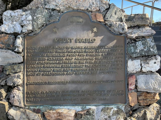
If you're in search of breathtaking views of the Bay Area, Mount Diablo State Park is the place to be. Rising over 3,800 feet, Mount Diablo offers panoramic vistas that span from the Sierra Nevada mountains to the Farallon Islands. Hike to the summit or drive up to the observation deck, and be rewarded with sweeping vistas, plus a historic visitor’s center where you can learn more about the area. There are a number of trails that take visitors to the summit while exploring the park on the trek there. We recommend the Mount Diablo Grand Loop Trail. This 6.2-mile trail gives hikers amazing views of the valley and ocean from many angles. Plus it’s a loop, so hikers can experience all new scenery the entire journey.
Monte Diablo, California 94598, EE. UU.
If you're in search of breathtaking views of the Bay Area, Mount Diablo State Park is the place to be. Rising over 3,800 feet, Mount Diablo offers panoramic vistas that span from the Sierra Nevada mountains to the Farallon Islands. Hike to the summit or drive up to the observation deck, and be rewarded with sweeping vistas, plus a historic visitor’s center where you can learn more about the area. There are a number of trails that take visitors to the summit while exploring the park on the trek there. We recommend the Mount Diablo Grand Loop Trail. This 6.2-mile trail gives hikers amazing views of the valley and ocean from many angles. Plus it’s a loop, so hikers can experience all new scenery the entire journey.
Mount Tamalpais State Park (also known as just "Mt. Tam") is home to the tallest mountain in Marin County. From Mt. Tam, you can see the Farallon Islands located 25 miles offshore, downtown San Francisco, and San Fransisco Bay.
226 Recomendado por los habitantes de la zona

Mount Tamalpais
Mount Tamalpais State Park (also known as just "Mt. Tam") is home to the tallest mountain in Marin County. From Mt. Tam, you can see the Farallon Islands located 25 miles offshore, downtown San Francisco, and San Fransisco Bay.